


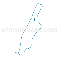
Voting District 7000071, New York County, New York
About
Outline

Summary
| Unique Area Identifier | 631640 |
| Name | Voting District 7000071 |
| County | New York County |
| State | New York |
| Area (square miles) | 0.14 |
| Land Area (square miles) | 0.14 |
| Water Area (square miles) | 0.00 |
| % of Land Area | 100.00 |
| % of Water Area | 0.00 |
| Latitude of the Internal Point | 40.81836300 |
| Longtitude of the Internal Point | -73.94992550 |
Maps

Graphs
Select a template below for downloading or customizing gragh for Voting District 7000071, New York County, New York


Neighbors
Neighoring Voting District (by Name) Neighboring Voting District on the Map
- Voting District 7000020, New York County, NY
- Voting District 7000027, New York County, NY
- Voting District 7000028, New York County, NY
- Voting District 7000038, New York County, NY
- Voting District 7000055, New York County, NY
- Voting District 7000057, New York County, NY
- Voting District 7000060, New York County, NY
- Voting District 7000067, New York County, NY
- Voting District 7000070 7000072, New York County, NY
- Voting District 7000073, New York County, NY
- Voting District 7000074, New York County, NY
- Voting District 7000076, New York County, NY
- Voting District 7000077, New York County, NY
- Voting District 7000078, New York County, NY
- Voting District 7000081, New York County, NY
- Voting District 7000082 7000083 7000094, New York County, NY
- Voting District 7000084 7000085, New York County, NY
- Voting District 7000087, New York County, NY
- Voting District 7000088, New York County, NY
- Voting District 7000089, New York County, NY
Top 10 Neighboring County Subdivision (by Population) Neighboring County Subdivision on the Map
Top 10 Neighboring Place (by Population) Neighboring Place on the Map
Top 10 Neighboring Unified School District (by Population) Neighboring Unified School District on the Map
Top 10 Neighboring State Legislative District Lower Chamber (by Population) Neighboring State Legislative District Lower Chamber on the Map
Top 10 Neighboring State Legislative District Upper Chamber (by Population) Neighboring State Legislative District Upper Chamber on the Map
Top 10 Neighboring 111th Congressional District (by Population) Neighboring 111th Congressional District on the Map
Top 10 Neighboring Census Tract (by Population) Neighboring Census Tract on the Map
- Census Tract 225, New York County, NY (10,149)
- Census Tract 223.01, New York County, NY (7,917)
- Census Tract 219, New York County, NY (6,023)
- Census Tract 213.03, New York County, NY (5,619)
- Census Tract 227, New York County, NY (4,864)
- Census Tract 215, New York County, NY (3,068)
- Census Tract 221.02, New York County, NY (2,175)
- Census Tract 217.03, New York County, NY (6)